Wow, a very rare tropical storm is tracking toward California. What to know.
Here’s a map you’ve probably never seen before.
A rare storm will make landfall in California. During the entire 20th Century, just one tropical storm — a cyclone from the tropics with sustained winds of at least 39 mph — hit the Golden State in 1939. Now, as of August 17, the National Weather Service reports that Tropical Storm Hilary will make landfall early Monday morning, likely somewhere along the U.S.-Mexico border. Hilary will strengthen into a hurricane over the warmer waters of the tropical Pacific before significantly weakening as it approaches the U.S.
Crucially, the storm’s behavior, track, and regional impacts will change in the coming days. But the big picture is clear: Parts of Southern California and the Southwest will experience heavy rainfall and flash fooding risk.
“People should prepare for heavy rainfall,” Zack Taylor, a meteorologist with the National Weather Service, told Mashable. “Regardless of the strength of the system, there is potential to bring significant impacts to the Southwestern U.S.”
In other words, just because the storm’s greatest risk isn’t wind and it will no longer be a hurricane (technically meaning sustained winds over 74 mph), the system still carries bounties of moisture.
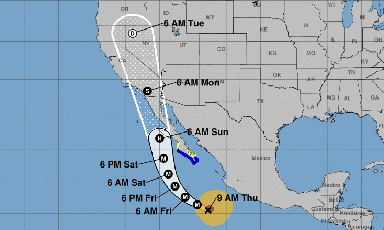
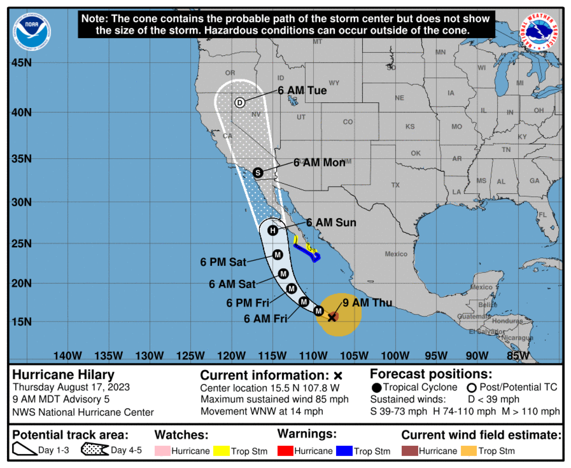
Tropical Storm Hilary track and impact predictions
Storms around the U.S., and world, are steered around by large areas of high and low pressure in the atmosphere. In this case, a trough (low pressure) over the Western U.S. and ridge (high pressure) over the central U.S. will steer Hilary on a path northward through Baja California.
A note about the storm track prediction: The predicted track you see below is shown by a cone, because the storm’s exact trajectory is based on evolving winds, ocean temperature, and beyond. The cone “represents the probable track of the center of a tropical cyclone,” the National Hurricane Center explains.
Here’s the predicted track as of 9 a.m. MDT on Aug. 17:
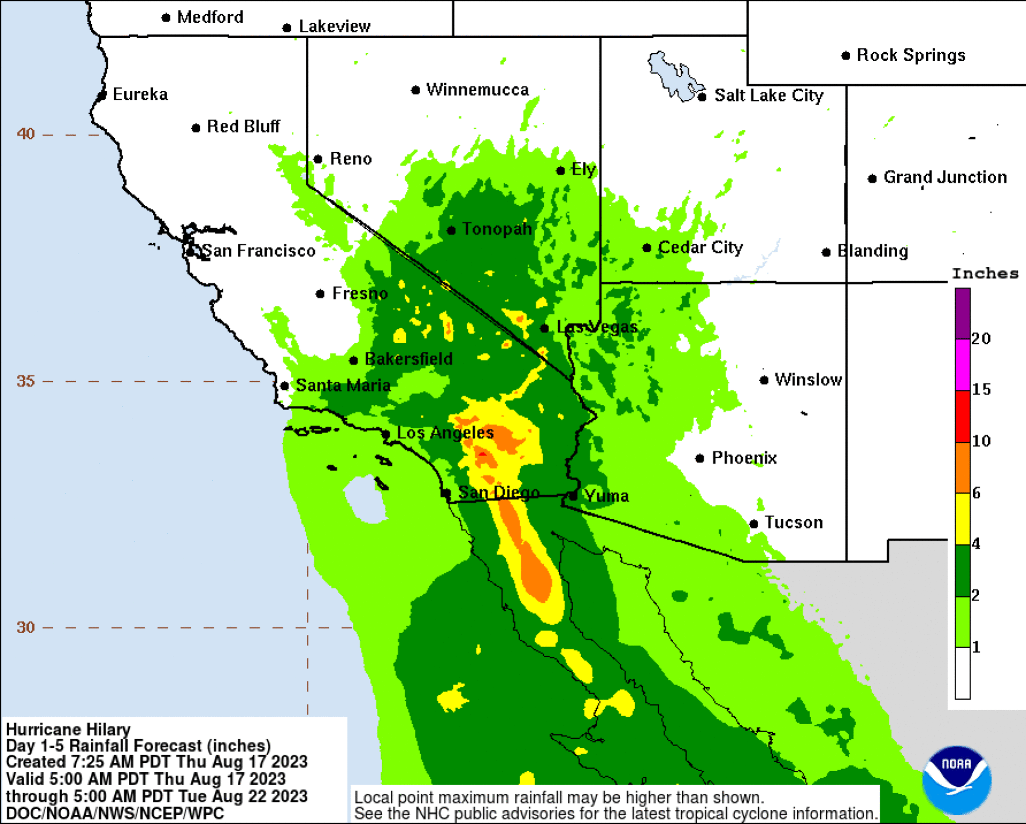
Intense rain and freshwater flooding will be the major impact in parts of Southern California, particularly flood-prone areas. “Heavy rain with the potential for flash flooding and debris flows remains the primary concern for So Cal Sun-Mon,” San Diego’s National Weather Service office wrote online.
The rains will peak Sunday and Monday in Southern California, Taylor said. But, importantly, rainfall estimates will be updated by the Weather Service over the coming days, he underscored.
Here is the rainfall prediction as of August 17. As of then, regions east of Los Angeles and San Diego will get the most rain, with some 10 inches at highest — though this can change.
Want more science and tech news delivered straight to your inbox? Sign up for Mashable’s Light Speed newsletter today.
Strong winds will be a factor, too, in some regions — but certainly not anything approaching hurricane winds. There’s a “20-30% chance tropical storm-force winds, beginning as early as Sun evening,” the National Weather Service said.
Fortunately, the Pacific waters off of Baja California are significantly cooler than the bathtub-like temperatures in the Gulf of Mexico and Caribbean — which act as “hurricane fuel” for intensifying tropical storms. Still, the impacts from Hilary can be serious, including not just rainfall and some high winds but dangerous coastal swells.
Stay tuned to your local National Weather Service Office.
“People should monitor the latest forecast as we hone in the latest details,” Taylor said.